Velibor Želi

MSc of Physics/Meteorology at the Department of Physics, Faculty of Sciences
  • Home
  • Research and Interests
  • Teaching
  • Weather Forecast
  • Blog

Weather Forecast

there should be an image here...

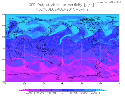
An animated image of GFS output showing absolute vorticity, forecast from 00 UTC on December 16, 2015, to December 20, 2015, at 00 UTC—a four day forecast—in six hourly intervals. This image was produced with the Grid Analysis and Display System (GrADS) and ImageMagick.

Link for the Weather Forecast @dpt of Physics can be found here.

In his paper F.G. Shuman in 1978, author used a very self-explanatory definition for Numerical Weather Forecast that didn’t change over the past years.

“Numerical Weather Prediction is a direct approach to Weather Forecasting in which physical laws governing the atmosphere are integrated from an initial state.”

From the given definition it is clear that Weather Forecasting is a very complex process. Atmospheric physicists/meteorologists are aware of the complexity of prognostic equations that govern the motion of the atmosphere. Since these equations can not be solved analytically we need to use various numerical procedures (e.g. finite differences) to find numerical solutions to these equations.

Besides the knowledge that is available for everyone to use, technology improved significantly. Today, ordinary PCs can be used as servers for a Regional Weather Forecast Model with a modest time-space domain. There are some Regional Weather Forecast models that are open-source and free to use e.g. The Weather Research and Forecasting model (WRF),  so not only professional atmospheric physicists/meteorologists but also anyone else willing to learn can have their own Weather Forecast up and running daily, producing forecast for the region of interest.

Weather Forecast at the Department of Physics in Novi Sad

Department of Physics in Novi Sad has its own Weather Forecast that started working at the end of November 2014. Both WRF cores that are available: Nonhyrdostatic Mesoscale Model (NMM) and Advanced Research WRF (ARW), produce weather forecast for the following 4 days over the south-eastern part of Europe. For initial and boundary conditions our both models use daily Global Forecast System (GFS) outputs that are free and available for everyone.

Link for the Weather Forecast @dpt of Physics can be found here. There you will find model output in the form of meteograms for 63 larger cities in the region. Aside from meteograms model output is available in the form of weather charts for different pressure surfaces in the atmosphere. All the images were produced with Grid Analysis and Display System (GrADS).

In the case of any problems or in need of information relevant to this Weather Forecast you can feel free to contact me any time.

  • Contact

© 2026 Velibor Želi